

SmartCultour celebrates World Heritage Day: Spotlight on adaptation to climate change through coastal development plans
The H2020 funded SmartCulTour project aims at supporting regional development in all European regions with important tangible and intangible cultural assets, including those located in rural peripheries and the urban fringe, through sustainable cultural tourism.
The International Day for Monuments and Sites 2022 (World Heritage Day 2022) takes place on 18th April, focusing this year on Heritage and Climate. As a project supporting the sustainability of cultural heritage within the sustainable tourism framework, SmartCulTour is working with 6 local community Living Labs to develop sustainable tourism approaches.
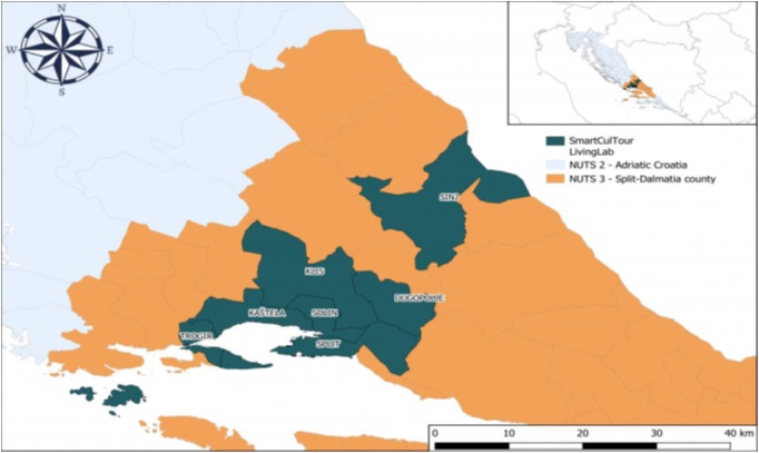
One of the goals of the international day is to ‘Force Login – hide your WordPress site safeguard all types of cultural heritage from adverse climate impacts’. The local authorities of the municipalities (which are members of our Split Living Lab – see Fig. 1), especially the coastal ones, have been very active in developing measures to adapt to climate change through implementing coastal development plans. Although this activity has neither been financed nor supported directly by the SmartCulTour project, we are reporting on this practice example provided by one of our Living Labs in order to help raise awareness about how climate change is impacting on our cultural heritage and how active solutions are being sought.
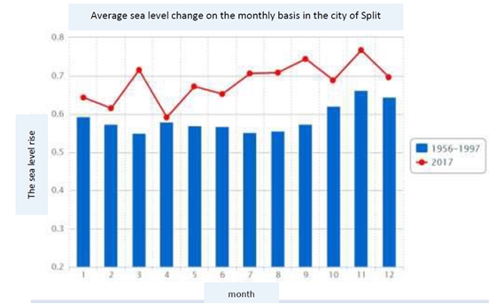
The impacts of climate change are felt in the whole Split Living Lab (LL) area, in terms of the growing temperatures, longer waves of extreme heat and consequently longer periods of drought, changes in precipitation amount and regime (with occasional strong showers causing flooding) and stronger winds. In addition, Split LL coastal cities, especially their historical centres, are located on a narrow coastal strip and are affected by a significant rise in sea level. Figure 2 shows a significant change in the average monthly sea-level increase in the city of Split from the 1956 to 1997 period (blue columns) compared to 2017 (red line) (Margeta et al. 2019[*]).
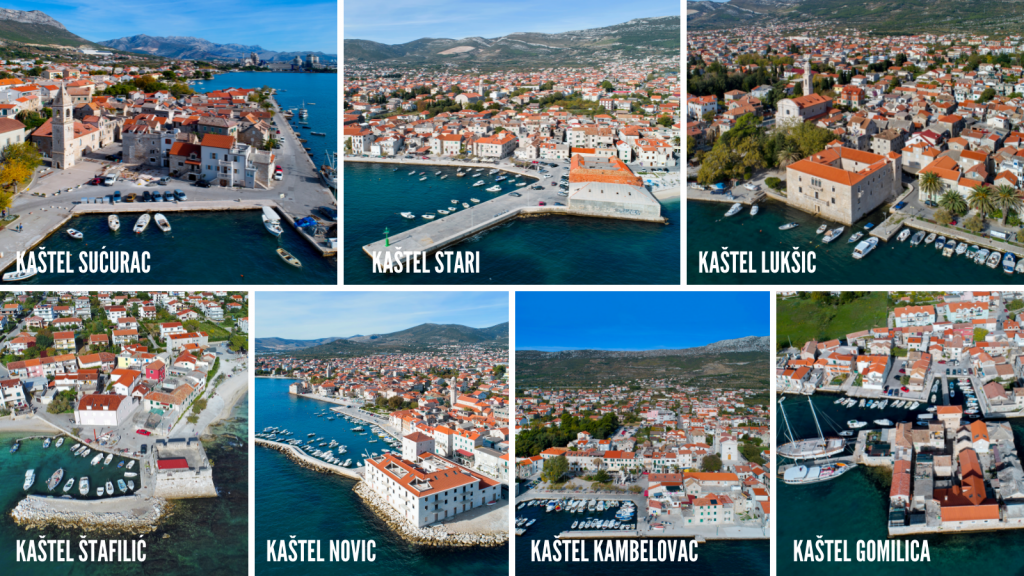
According to Margeta et al., 2019, the city of Kaštela has experienced a 30 cm rise in seal level over the last hundred years and in response has developed a Coastal zone management plan foreseeing several adaptation scenarios to combat climate change. The plan defines the development of an action plan based on integrated coastal zone management and maritime spatial planning. The goal of the Coastal Plan is the sustainable development of the coastal area based on tourism with a focus on measures to protect the sea coast that is particularly vulnerable to climate change. Some of the solutions proposed by the Plan to strengthen the resilience of the coastal strip and its infrastructure to climate change are already being implemented. These include infrastructure enhancements close to the heritage buildings within the old historical cores of the seven Kaštela municipalities that are the most endangered by the sea level rise (Figure 3).
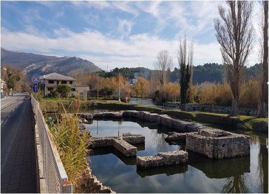
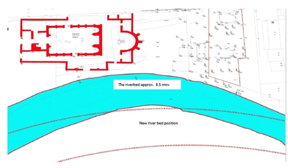
Another interesting solution in the City of Solin aims to mitigate climate change impacts and protect important historical remains (Katić, M., Bucat, M. 2022[*]). The city is rich with monuments from the Roman period and the early mediaeval ages when it was the seat of the early Croatian rulers. One of the most important monuments of that period are the remains of the so-called Hollow church (dedicated to St. Peter and Moses), the coronation basilica of the Croatian King Zvonimir (11th century A.D.). While in the eleventh century, it was above the level of the adjacent river Jadro, the ground level of the church is today situated below the height of the river (Figure 4). The terrain is flooded due to several factors, among others due to underground springs and the rise in sea level, considering that the river´s sea estuary is not far from the remains of the church. Therefore, the city of Solin has developed a plan to displace the course of the river a few meters away to protect this important archeological site from flooding (Figure 5). Although being technically and financially challenging, the project is a good example of partnership and cooperation among different experts and stakeholders, for example archaeologists (from the Museum of Croatian archaeological monuments in Split), architects (from the architectural bureau “Arhitektonski kolektiv” in Split), the City of Solin administration and the Croatian legal entity for water protection “Hrvatske vode”.
Margeta, J.,Baučić, M., Vilibić, I., Jakl, Z. Petrić, L., Mandić, A., Grgić, A., Bartulović, H.,,Popić, N., Marasović, K.,Jajac, N., Rogulj, K., Ivić, M., Jovanović, N., Bačić, S., (2019), The city of Kaštela Coastal Zone Management Plan, Faculty of Civil Engineering, Architecture and Geodesy, University of Split. Document financed by the ERDF, within the Interreg Med project CO-EVOLVE, pg. 16 (retrieved from: https://www.kastela.hr/projekti/plan-upravljanja-obalnim-podrucjem-grada-kastela).
Katić, M., Bucat, M. (2022). Budućnost starohrvatskih lokaliteta Rižinice i Šuplje crkve u Solinu, power point presentation from the 8th International Congress of the Historic Cities, Solin, 29/3/2022-1/4/2022.